Why Is Oklahoma the Heart of Tornado Alley?
If you have lived in Oklahoma for any length of time, you know “the look.” It is that eerie, bruised-purple sky that settles over the plains on a humid Tuesday in May. You know the smell of the air when the wind shifts suddenly from the south to the west. Most importantly, you know the sound of the sirens.
I have spent decades watching the horizon in this state. I have seen the clouds rotate, felt the pressure drop until my ears popped, and spent more hours than I can count huddled in a shelter with a battery-powered radio. To outsiders, our weather seems like a chaotic fluke of nature. To us, it is a scientific certainty.
But why here? Why does this specific patch of red dirt attract the most violent windstorms on the planet? The answer is a perfect, albeit terrifying, intersection of geography, physics, and atmospheric timing.

The Geographic Crossroads of North America
Oklahoma sits at a unique atmospheric crossroads. To understand our tornado frequency, you have to look at the map of North America as a giant mixing bowl. We are located exactly where three very different types of air masses collide.
-
Warm, Moist Air: This flows up from the Gulf of Mexico. It is heavy, humid, and full of the energy needed to fuel a thunderstorm.
-
Cold, Dry Air: This sweeps down from the Canadian Rockies. It is dense and acts as a wedge, pushing the lighter, warm air upward.
-
Hot, Dry Air: This comes off the high deserts of the Southwest. This air mass often forms what meteorologists call the “dryline.”
When these three players meet over Oklahoma, the atmosphere becomes a powder keg. There is no other place on Earth where these specific air masses interact with such regularity and intensity.
The Role of the “Dryline”
In Western Oklahoma, we often talk about the dryline. Think of it as an invisible boundary between the humid air of the eastern part of the state and the desert air from the west.
Why does this matter? Because dry air is heavier than moist air at the same temperature. As that dry desert air pushes eastward, it slides under the moist Gulf air like a spatula, flicking it high into the atmosphere. This rapid upward movement is the birth of a supercell.
Have you ever wondered why a storm seems to “explode” out of nowhere near towns like Altus or Elk City? That is the dryline at work. It provides the initial lift required to break the “cap” and start the convection process.
Atmospheric Instability and “The Cap”
Meteorology in Oklahoma is often a battle against “the cap.” The cap is a layer of warm air a few thousand feet above the ground that acts like a lid on a boiling pot.
Throughout a spring morning, the sun heats the ground. The air near the surface gets hotter and more humid. It wants to rise, but the cap holds it down. Pressure builds. Energy accumulates.
If the cap is too strong, nothing happens, and we have a “blue sky day.” But if the sun’s heat or an approaching front manages to poke a hole in that lid, all that pent-up energy rushes upward at once. This is why Oklahoma storms are often so explosive. We go from a clear afternoon to a 60,000-foot-tall supercell in less than an hour.
Wind Shear: The Secret to Rotation
A thunderstorm is just a big rain cloud. A supercell, however, is a rotating beast. To get a tornado, you need that rotation. This is where wind shear comes into play.
In Oklahoma, we experience significant “vertical wind shear.” This means that as you go higher into the sky, the wind changes direction and increases in speed.
-
At the surface, the wind might be coming from the South at 15 mph.
-
A mile up, it might be blowing from the Southwest at 50 mph.
-
Two miles up, it might be screaming from the West at 100 mph.
This difference in speed and direction creates a rolling effect in the atmosphere, much like rolling a pencil between your hands. When a powerful updraft catches that horizontal roll and tilts it vertically, the entire storm begins to spin. This rotating updraft is called a mesocyclone. Without Oklahoma’s unique wind patterns, these storms would just be heavy rainmakers instead of tornado producers.
The Impact of Flat Terrain
People often ask if hills or trees can stop a tornado. As someone who has seen these storms move across various landscapes, I can tell you: the terrain of the Great Plains offers no resistance.
The relatively flat landscape of Oklahoma allows storms to maintain their structural integrity for hundreds of miles. There are no mountain ranges to disrupt the inflow of moist air or to break up the wind shear. This “unimpeded runway” allows a storm that starts in the Texas Panhandle to stay organized all the way across Oklahoma and into Missouri.
Why the Spring Season is So Violent
While we can have tornadoes in December or October, the “Big Three” months are April, May, and June. This is because the jet stream—a river of fast-moving air high in the atmosphere—is migrating north during this time.
In the spring, the jet stream sits directly over the Southern Plains. It provides the “exhaust system” for our storms. Just as a fireplace needs a chimney to draw the smoke up and keep the fire burning, a supercell needs the jet stream to pull air away from the top of the storm. This keeps the updraft strong and allows the storm to breathe.
Life in the “Tornado Alley” Bullseye
Living here requires a certain level of respect for the sky. We don’t live in fear, but we do live in preparation. Oklahoma has some of the most advanced meteorological infrastructure in the world, including the National Weather Center in Norman.
However, even the best radar can’t stop a wind that exceeds 200 mph. We have seen what happened in Moore in 1999 and 2013. We remember the May 3rd outbreak. These events aren’t just history to us; they are reminders of why we build the way we do.
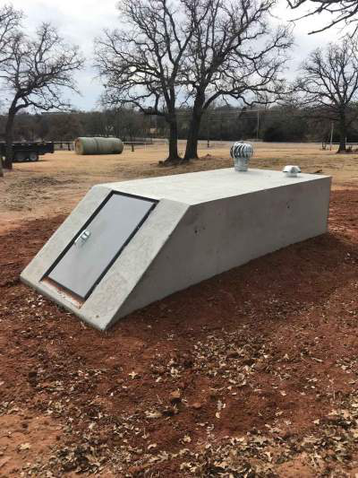
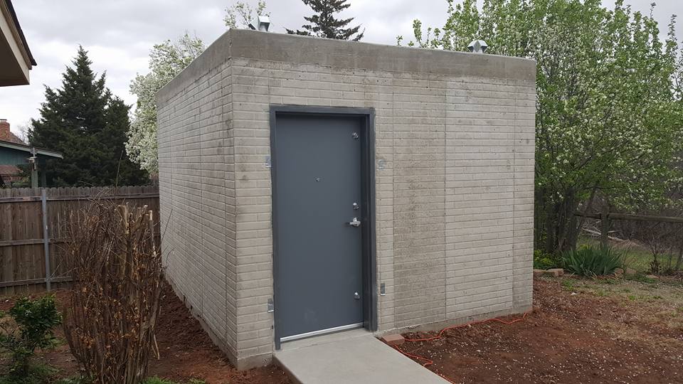
The Necessity of Storm Shelters
If you are an Oklahoman, you know that a “safe room” isn’t a luxury; it’s a standard part of a home. Because of the sheer power of EF4 and EF5 tornadoes, being “underground” or inside a reinforced steel box is the only guaranteed way to survive a direct hit.
Why a shelter is your best defense:
-
Structural Integrity: Modern shelters are tested to withstand the impact of a 2×4 being shot at 250 mph.
-
Peace of Mind: You no longer have to wonder if the interior closet is “good enough.”
-
Property Value: In Oklahoma, a home with a storm shelter is significantly more desirable than one without.
Frequently Asked Questions About Oklahoma Tornadoes
Does the “Green Sky” really mean a tornado is coming? Not necessarily, but it is a sign of a very tall, severe storm. The green tint is caused by sunlight reflecting through massive amounts of ice and hail inside the cloud. Since large hail and tornadoes often go hand-in-hand, it is a signal to take cover.
Can tornadoes be “skipped” by cities? This is a dangerous myth. There is no “bubble” over Oklahoma City or Tulsa. Tornadoes do not care about heat islands or city lights. They go where the atmospheric conditions take them.
What is the “Enhanced Fujita” Scale? We measure tornadoes by the damage they cause, not their size.
-
EF0-EF1: Weak (65-110 mph) – Causes roof and tree damage.
-
EF2-EF3: Strong (111-165 mph) – Can lift cars and collapse walls.
-
EF4-EF5: Violent (166-200+ mph) – Can sweep well-built homes off their foundations.
How to Stay Safe During Tornado Season
Survival in Oklahoma comes down to two things: Information and Protection.
-
Have Multiple Ways to Get Alerts: Don’t rely on sirens. They are meant for people who are outdoors. Use weather apps, a NOAA weather radio, and local TV news.
-
Know Your Plan: Don’t wait until the sirens go off to decide where to go. If you don’t have a shelter, know which neighbor does, or identify the lowest, most central room in your house.
-
Keep a “Go Bag” in Your Shelter: Include helmets (crucial for head protection), shoes, a flashlight, and your ID and insurance papers.
Resilience in the Face of the Wind
There is a unique bond among Oklahomans. We are a people who help our neighbors clear debris before the clouds have even finished clearing. We understand that we live in a beautiful, but sometimes volatile, environment.
The science tells us why Oklahoma is so prone to tornadoes. Geography has handed us a difficult hand when it comes to weather. But science also gives us the tools to stay safe. Through better building practices and high-quality storm shelters, we have turned “Tornado Alley” from a place of tragedy into a place of resilience.
If you are concerned about the upcoming season, or if you have recently moved to our great state and realized that your new home doesn’t have a plan for the wind, don’t wait. The atmosphere over Oklahoma is always changing, and the next big storm is never a matter of “if,” but “when.”
Get Prepared Today
Don’t let the next “bruised-purple sky” catch you off guard. We specialize in providing Oklahomans with the peace of mind they deserve through industry-leading storm shelters.
Contact us for a free consultation:
-
Email: sales@oklahomashelters.net
-
Expertise: Over two decades of protecting Oklahoma families.
Stay weather-aware, stay prepared, and remember: in Oklahoma, we don’t just survive the storm—we respect it.